|
I finished editing my photos. You can find them here: https://littlemilligan.myportfolio.com/washington-and-oregon-1
All totaled our journey was 41 days. We drove approximately 4,200 miles. We stayed in 20 different hotels. We visited 10 national parks, monuments, forests, or recreation areas, 23 state parks or natural areas, 9 lighthouses, 4 botanical gardens, 6 museums, and drove on 8 scenic byways.
0 Comments
We loaded the our rented Rav4 for the last time. We left Astoria by 8:30. We made it to Seattle by 11:00. We had lunch at the Chic-Fil-A within a mile of the airport.
We returned the car, which was more like a fast moving assembly line. They just looked at the outside of the car and we turned in the keys and headed for the bus ride to the terminal. We made it with about 15 minutes to spare to the turn-in time. After checking our bags and going through TSA quickly we found us a place close to our gate that wasn't very crowded and waited until the 4:50 boarding time. Boarding was easy and the flight was uneventful. Arriving at the airport was another story. The plane arrived on time, 11:40, and we found our luggage easily. However due to construction and three big planes that all landed at the same time, there was much traffic. It took poor Meredith about an hour or more to get to us. We didn't make it back to her house until almost 1:30. We stayed on Friday to visit and left on Saturday after Sam's soccer game. We made it to Jefferson City around 6:30. On Thursday we drove 173 miles. And for the first time I did not record our mileage from Meredith's. So our journey was a 41 day journey, almost Biblical in many ways. I have a lot of editing to do since my old laptop wasn't really capable of doing much editing on the trip. When I finish I will put a link to my online portfolio with my images. Today is our last day of touring. Tomorrow we drive to Seattle and fly to Meredith's. We had our hotel breakfast and left the hotel about 7:45. First stop was the Astoria Column. The Astoria Column tells the story of the Lewis and Clark Journey and the founding of Astoria.It is high on a hill with great views of the Columbia, the Astoria Megler Bridge, and Washington. We drove across the Columbia on the bridge and went to Cape Disappointment, so named by Captain Meares who thought he had found another passage to the interior. We hiked to the Cape Disappointment Lighthouse on the trail that goes past Deadman's Cove. On the way back from the lighthouse we got a little shower but we were prepared with rain gear. Luckily this was the only rain we got on this mostly cloudy day. We visited the Lewis and Clark Interpretive center on the way back now that it was open. We drove to the North Lighthouse and did a short loop trail to see it. It was in much better condition than the other lighthouse on the cape. We drove back down to the boat launch and found a covered dry bench for our last picnic lunch We made a brief stop at Fort Columbia and a turn out to see the bridge from the Washington side. We drove back across the bridge and up to the Astoria Column again. This time it was open and I tried to climb the 169 stairs to the top but they were spiral, narrow, metal stairs and I got to scared to go to the top, especially since by now there were no views with the cloudy sky. We stopped by a thrift store on the way back to donate my boots. They were great but not enough room to fly back. We drove by the Riverwalk and I took pictures from the Oregon side of the bridge. We got gas for the last time: 7.5 gallons, $41.23. Back to the hotel for our last soup and sandwich supper. We cleaned out the car and re-organized our bags for airplane travel tomorrow. Nightly chores for the last time! Hurrah! We drove 102 miles today and Karen walked 6.9. 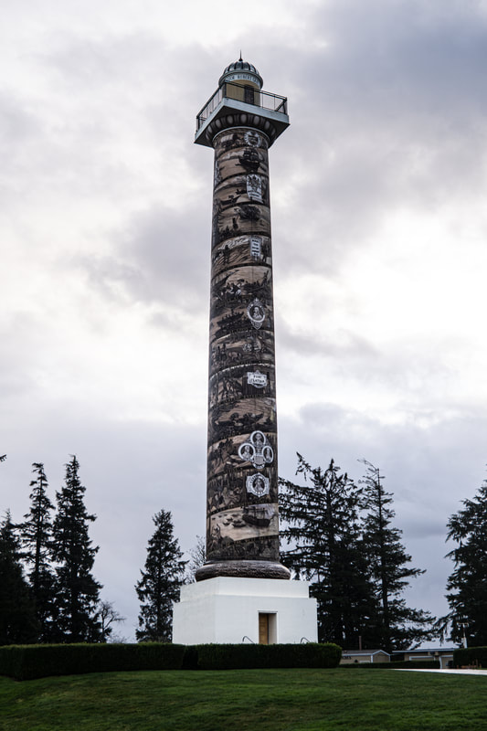 Astoria Column 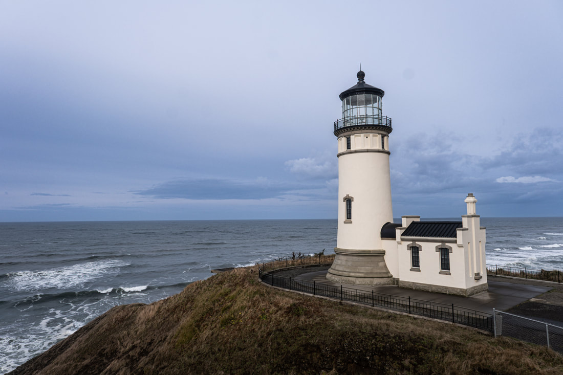 Cape Disappointment North Lighthouse We packed up and left the hotel by 7:45 under cloudy but not raining skies. We headed up 101 for Astoria and the rain started about 15 minutes into the drive. Our first stop was Fort Stevens State Park. This for was built in the Civil War and in World War II it was the site to protect the Columbia River. It was the only spot on the continental US hit by Japanese. Missles were sent from the Japanese sub but did not damage. Their aim was to start fires along the coast, which was difficult with the rain and there were no further attacks. The fort did not fire back since they knew the submarine was out of range and they did not want to give away their location. We went to the visitors center and since it wasn't open yet we walked on the grounds to the ocean to se the Astoria Bridge and Washington on the other side. It started to rain so we made it back to the car without getting too wet. We toured the little museum. Our next stop was Fort Clatsop Lewis and Clark Intrepretive Center. This is the place where the Corp of Discovery spent their second winter. There is a replica of the fort here. On our trip last year we visited several Lewis and Clark site including Fort Mandan where they spent their first winter. We got a little break in rain to see the replica of the fort but we just didn't want to hike on the trail to the ocean in the rain. We headed into Astoria hoping to find a fast food restaurant for lunch but there were only drive thrus so we had lunch at Pig N' Pancake, a local Shoney's like chain in Oregon. By now it was raining very hard and the wind was blowing 15mph so we decided to just head to the hotel and wait there. Luckily they had a room ready for us. We were unloaded and in the room by 2:30. We had our soup for supper. We will have about half a day tomorrow with only partly cloudy skies to visit the Washington side of the Columbia and a little more of Astoria. Then we pack for the flight home on Thursday. Miles driven today: 37. Karen only walked 3.4 miles. 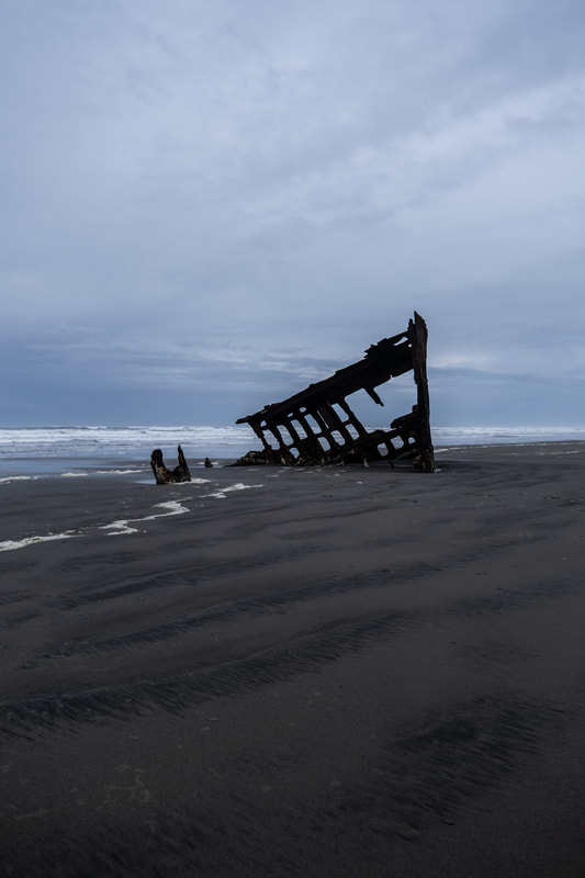 Remains of the Wreck of the Peter Irdele that wrecked in 1906 at Fort Stevens 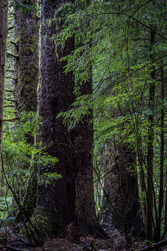 Cedar Trees at Fort Clatsop, the fort is in a beautiful forest. The short tree is about 8 ft tall. I learned from an Oregonian at the conference that they call them sun breaks, when the sun breaks through the clouds on a rainy day. This is what we had today, a day we thought was going to be total rain. It was raining when we got up and it rained until 10 so we just stayed in our room and had our usual non-motel breakfast At 10 we had a sun break and headed to the next town north, Seaside. It is kind of like and very miniature Pigeon Forge at the beach. We had hoped to find a cheap McDonalds but it was only doing drive thru. We did find Ruby's Roadside Grill which was moderately priced and had a great BBQ basket. After lunch we drove around the town and found the road to the beach lined with gift shops. We also find the Lewis and Clark monument. This was the furthest place south they went on the Pacific. We also found the Safeway and got our reliable frozen stuffed peppers and microwave rice for supper. It started raining again on our way back to Cannon Beach. After we dropped off our supper in the fridge we got another sun break so we went to Ecola State Park. When we got there there were blue skies and some gray skies so we started down to the viewpoint. About 3 minutes into the walk the rain started, hard this time with blowing wind. I ran to the shelter to cover my backpack and camera with my poncho and Thomas ran to the car. After a very short time, the rain stopped and it was sun break again. I went back to the viewpoint with my poncho - we both had on rain coats all day everyday anyway - I Just use the poncho as a quick way to cover my back pack and camera. We could see the storm clouds coming this time so we headed back to the hotel. We rested and Thomas prepared our supper. When we finished I looked out the window and saw color in the sky. There wasn't much color but I made it to the beach and Thomas followed. Back to the room for nightly chores and what Thomas does while I work on my pictures and the journal, a cup of decaf coffee. Today we only drove 37 miles and Karen walked 5.4. Tomorrow we will go to Astoria and stay in our last hotel. It is supposed to rain tomorrow but there is always the possibility of a sun break. 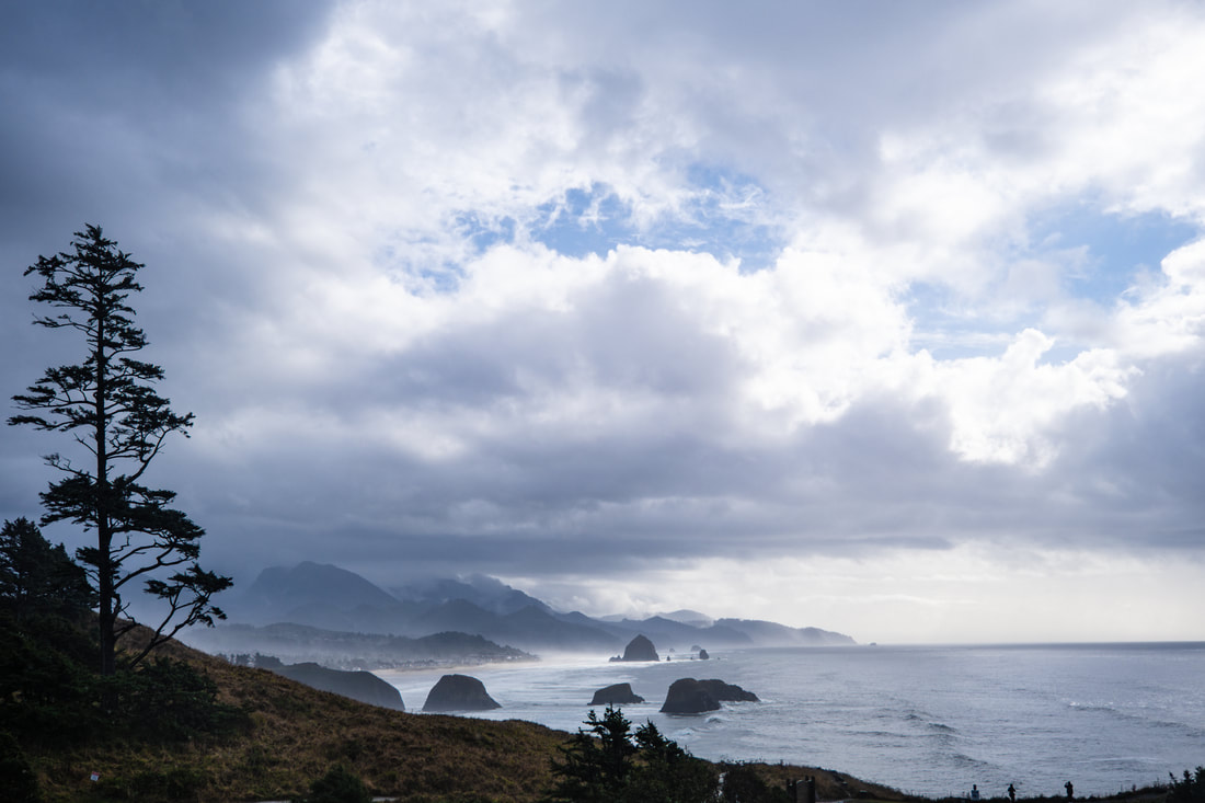 Haystack Rock from Ecola State Park We packed up and left our little cottage by the sea by 7:45. We drove by Oceanside Beach on last time but there wasn't much color as yesterday. There was still some fog but the skies were clear. We headed north on 101 again and got gas in Tillamook, 6.1 gallons for $30.19. We stopped at a few overlook and went down to the beach at Hug Point for a short walk. We drove through Canon Beach on to Ecola State Park. We could see Haystack Rock and the Tillamook Lighthouse off shore, nicknamed Terrible Tilly. We hiked a short way on the Indian Beach trail to the top of the point. We then drove on to Indian Beach. There were surfers again even though it is 50 degrees. We had a picnic lunch here in the sun and walked down on the beach. We drove back to town to check on our motel. The room wasn't ready so we decided to walk around the shops downtown. We had a crepes from a window - it reminded me of the Nutella crepes we got in Paris. We got a call that our room was now ready so we drove back to check in. Along the way there was a little heard of elk walking down the road. After checking in and unpacking we drove back to town to walk down to Haystack Rock. We realized that it was just a long to walk from the public parking lot as it would be to walk from the beach across the road from our hotel. We went back to the hotel and had our soup for supper. We walked to the beach but the clouds covered the sun. We didn't get a sunset but we did get to see tide pools. It was really cool to see one finally. As it got dark it was a long walk back to the hotel, altogether that walk was 2.5 miles. We rested a little and did nightly chores. The weather forecast is for rain and wind all day. Earlier in the trip we braved the rain but we are getting a little tired and will probably just watch it rain from the comfort of our hotel. We drove 73 miles today and Karen walked 9.8 miles. 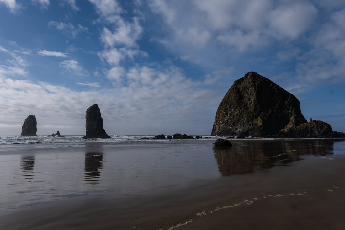 Haystack Rock and the Needles 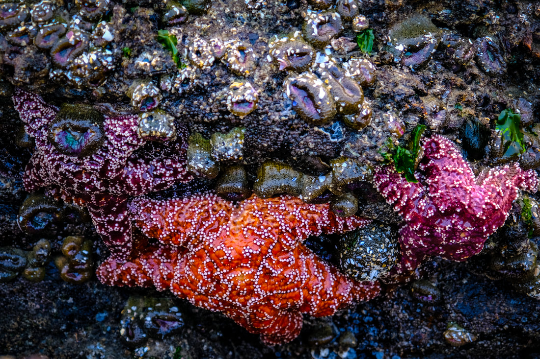 Sea stars in the Tidal Pools around Haystack Rock Today was another gift. The forecast last night at bedtime was for rain and thunderstorms all day. We decided that we would just get to do one inside thing, visit the Tillamook Creamery. Since it didn't open until 10 we didn't set an alarm. I woke up at the regular time, 6:00 and checked the weather first thing. Partly cloudy was the prediction until around 11. Out the window there were blue skies. So we got ready and left the house around 8 to just go down to Oceanside Beach, only about 5 miles from our cottage, to see the beach. It was beautiful. This is an interesting beach. At low tide there is a sea tunnel that has been reinforced by concrete that you can walk through to get to Agate Beach, also called Lost Beach. It was great. After this since it still wasn't raining we decided to go back to Cape Meares. It was even more amazing with blue skies and golden hour. Still not raining and a little after 10 so we decided to go on to Tillamook Factory. We did the self guided tour and since it was 11 we got our special lunch here: fried cheese curds, tomato soup, and Mac and cheese. We did this just right also, since there was no line when we ordered and when we finished the line was very long. There were still clear skies to the north and even though I didn't bring the itinerary we decided to go on north as far as Oswald West State Park. We took a beautiful trail, Short Sands Trail, through and old growth forest down to a Cape Falcon. This was one of the best trails we have taken. It was short but filled with beauty. We saw the storm clouds gathering so we headed back to the car. We did go through a short, heavy rain storm on the way back to the cottage. After we unloaded and I cleaned by tripod, it started raining again. We had a snack supper since we had such a big lunch. The sky cleared and we decided to try a sunset at Oceanside Beach. It was beautiful. Back to the cottage to organize for leaving tomorrow and nightly chores. Miles Drive: 96. Karen walked 6.5 miles. 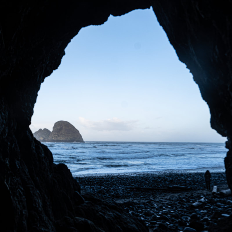 Looking out of the sea tunnel to lost beach 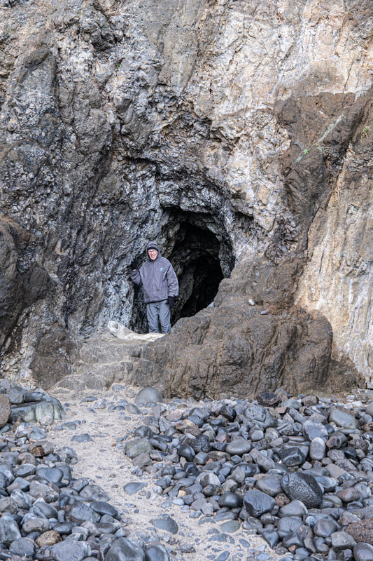 Grandaddy coming out of the sea tunnel onto lost beach 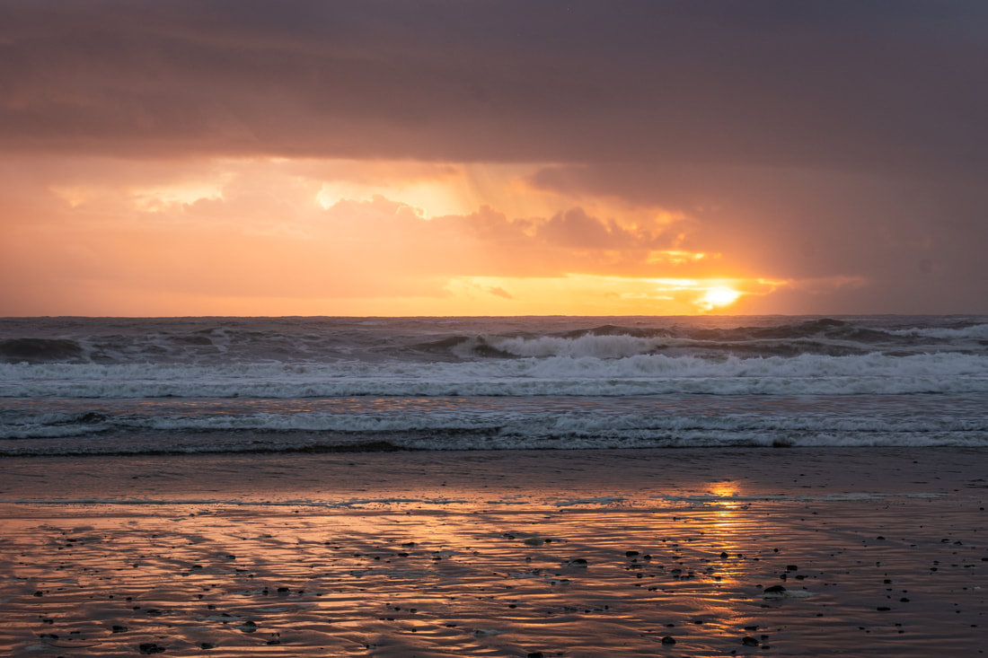 Sunset at Oceanside Beach Today was a windy, rainy, foggy day. We began by going to Cape Meares. It was only foggy here since the rain was not supposed to start until 10. We walked down to the lighthouse. This is the shortest lighthouse on the coast, only 38 feet tall - but it is on an 80 foot cliff. It is no longer operational and it is closed for the season so we couldn't go inside. The trail allowed you to see the lens like Herceta Head. We walked along the trail overlooking the cape. Also here is the Octopus Tree. This 250-300 year old tree has split into multiple trunks. It is considered a heritage tree by the state of Oregon. Our next stop on the Three Capes Loop was Cape Lookout. On a clear day it is said that you can see 40 miles in either direction on a clear day. However we couldn't even see the end of the point. Karen walked a little on the beach as the rain had started. We continued on to Cape Kiwanda. The rain had stopped momentarily so we walked on this beach with the giant sea stack and arched cave. There were also several people surfing in this cold rainy weather. As we walked on the beach it started to rain again so we went back to the car. Our next stop was Neskowin State Park. We were hoping for a picnic shelter but there wasn't one. We fixed our sandwiches in the car and since the rain and stopped again we ate standing up at a tree covered picnic table. We went down to the beach to see Proposal Rock and Cascade Head. It started raining again so back to the car. We drove on to Lincoln City were we got 7.5 gallons of gas for $37.81. Our next stop was Depot Bay. This is the smallest natural harbor on the coast. It is a keyhole harbor. We did get a view of the harbor and bridge, but it was raining again so we didn't do any other walking. We headed back to Tillamook to the Safeway; to get groceries for supper. There was pasta and spaghetti sauce at the AirBnB so we got salad and some garlic bread. This was the first time we fixed supper and washed dishes since we left home. Tomorrow it is supposed to be raining again but with the addition of thunderstorms. We will probably just go to the Tillamook Creamery for a visit and lunch and won't be able to do the other things we had planned in the area. Miles driven today: 136. Karen walked 6.2 miles. 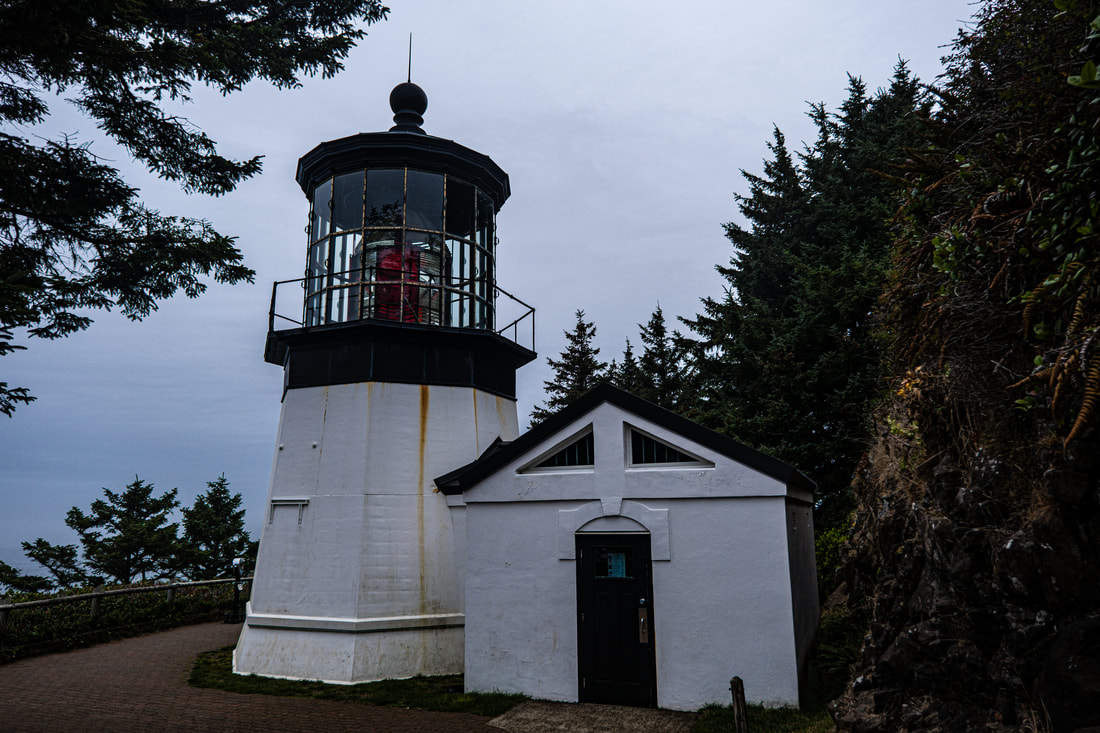 Cape Meares Lighthouse This was the last half day of the conference. I don't feel I learned as much or had a good experience as the conference in 2018. Some of that was due to the last minute changes in instructors who got COVID and had to cancel. Karen's morning sunrise shot was at a beach with a view of the lighthouse. However there was fog and the tide was coming in on this very narrow beach. My car, which I really enjoyed being with all week, decided to head out early and go to take a picture of the bridge. We got lucky and got some good shots. We had our last announcement session and a big breakfast. Thomas had already packed the car so we left quickly. We decided to head back north to a couple of places that I thought we would visit during the conference but didn't. Devils Churn in the Cape Perpetua area was really neat. The waves were crashing big in this chasm. We drove just a little further back to the Hereto Head Lighthouse that we visited on Sunday. This time I did hike up the hill above the lighthouse and got a good image of the lens. It was still a little foggy. We started our northward journey and stopped at the Yachita Head Lighthouse. I really wish that we had gone there Monday afternoon when the skies were clear. It was socked in but it was still neat. It had a nice visitors center. There were also Tidepools here. I was hoping to see some of those during the week but they weren't on the agenda. Maybe I will get to see some this week. After the lighthouse we stopped at Otter Rock to see the Arch Rock and then at Cape Foulweather. Still mostly foggy. We did get to stop at the famous little observation/gift store that was built in the 1930s. We continued on to our little AirBnB cottage. It is on the bay. It is well-equipped and I think we will enjoy staying here. Rain is supposed to start tomorrow and continue for the rest of the time we are on the coast. This was a big driving day: 168 miles. Karen walked 6.4 miles.  Hereta Lighthouse This conference day 3 for Karen. Karen left for her sunrise shoot at 6:15 to Cape Perpetua. This area is known for its high waves and rock feature. The one iconic feature is Thors Well, a cave that opens from underneath and fills with surf. It was a difficult climb to get down to the feature. It can also be a dangerous place. We did see another photographer not with the conference get knocked over by the wave. I did get my one shot and then quickly moved away to some other features that I could view at a safer distance. One interesting one was Spouting Horn, another sea gave that shoots waves up through an opening. We were back by 10 today and the Table Sessions were still outside. The weather changed quickly and it got very foggy and windy. We ate our lunch quickly and headed back to the room. Thomas washed clothes. The other task we had to do was to re-rent the car for the last week. Cars can only be rented for a month. The information and instructions we got about what to do changed every time we talked to someone at Enterprise. Finally we got it settled and luckily there is an Enterprise dealer in Newport. So after about an hour we got everything settled. We made a quick stop at Walmart to get food for our trip tomorrow. The evening sunset was not very good since everywhere is sacked in with fog. There was hardly any color in the sky. We headed back by 7:00. Nightly chores. Karen walked 5.12 miles today. 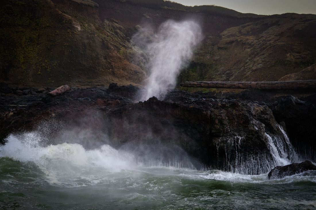 Spouting Horn at Cape Perpetua |
Journey JournalWhen we have Internet connection I will add a post. |
 RSS Feed